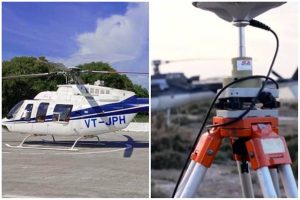
The ground survey for the proposed 1,115-kilometer East Coast Dedicated Freight Corridor will be conducted by the Dedicated Freight Corridor Corporation employing laser-enabled equipment placed on a helicopter using the light detection and range survey (LiDAR) technology.
The corridor begins in West Bengal’s Kharagpur, travels through Odisha, and ends in Andhra Pradesh’s Vijayawada (Tenali). Baleshwar, Bhadrak, Khordha, Bhubaneswar, Rajahmundry, Visakhapatnam, and Vijayawada will be connected.
For the purpose of the airborne LiDAR survey, 300 metres of area around the suggested alignment will be recorded.